
- Working Hour: 09.00am - 05.00pm
- Email: sales@sohanscientific.in
- Email: jankee@sohanscientific.in
FS 60 UAV Hyperspectral Measurement System
The FS 60 system uses a **high signal-to-noise ratio** and **ultra-high-speed CCD** imaging device for highly stable spectral image acquisition. Its self-developed, high-efficiency, and **low-power image processing** algorithm significantly extends flight endurance.
This system provides real-time spectral information for **plants, water bodies, and soil**, making it essential for **precision agriculture** 🌾, crop yield evaluation, forest pest/fire monitoring, and aquatic environment surveillance.
Core Specifications
- ▶ **Spectral Range:** 400–1000nm
- ▶ **Max. Load:** 10 kg
- ▶ **Max. Endurance:** 60 minutes (with 3 kg load)
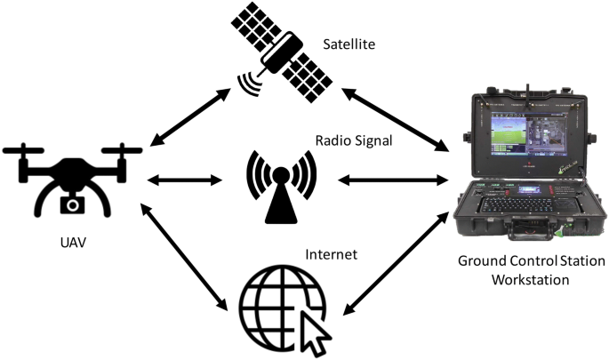
- ▶ **Ground Station Range:** 10 km radius
- ▶ **Control:** Remote intelligent control via Bluetooth
- ▶ **System Components:** Imager, Gimbal, Storage, GPS, Ground Station.
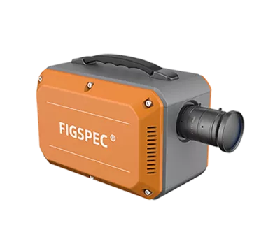
Hyperspectral Camera Features 📸
- • Spectral band range: **400–1000nm**
- • Spatial dimension resolution: **1920 pixels**
- • Maximum number of spectral bands: **1920**
- • Spectral resolution: **2.5nm**
- • Supports **multiple data formats** for perfect compatibility.
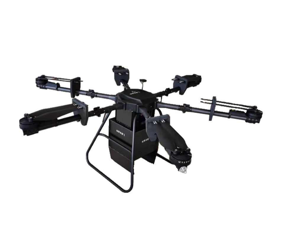
UAV System Highlights 🚁
UAV System Highlights 🚁
- • Maximum flight endurance: **60 minutes** (with 3kg payload)
- • Maximum payload capacity: **10kg**
- • **Easy to operate** by a single person; no need for a professional UAV operator.
Airborne System Measurement Characteristics 🛰️
- • **Real-time observation** of sampling location via ground station.
- • Supports point-by-point route setting for **precise flight paths**.
- • Data corrections (Radiance, Reflectivity, Area) support **batch processing**.
- • **Real-time vegetation index calculation** function.
- • User-defined real-time analysis model input function.
Diverse Application Areas
Utilize the FS 60 system for critical data across numerous fields.
- ① Geological and mineral resources survey
- ② Precision agriculture, crop growth, and yield assessment
- ③ Forest pest monitoring and fire prevention monitoring
- ④ Coastline and marine environment monitoring
- ⑤ Grassland productivity and monitoring
- ⑥ Lake and watershed environment monitoring
- ⑦ Remote sensing teaching and scientific research
- ⑧ Meteorological research
- ⑨ Ecological environment protection and mine environment monitoring
- ⑩ Water quality detection, soil monitoring
- ⑪ Quality detection of agricultural and livestock products
- ⑫ Military, national defense, and homeland security
- ⑬ Disaster prevention and control
Technical Parameters
| Serial No. | Index | Parameter | Remarks |
|---|---|---|---|
| 1 | Spectral camera spectral range | 400–1000nm | / |
| 2 | Spectral resolution of spectral module | Better than 2.5nm | Up to 1.9nm |
| 3 | Spectral resolution of lens | 0.9mm | 32mm lens |
| 4 | Number of spectral bands | 460/640/1920 | Depending on spectral range |
| 5 | Number of spatial channels | 1024 | 4 pixels (center) not combined |
| 6 | Pixel number of spectral camera | 1024×1024 | / |
| 7 | Spectral camera frame rate | 60Hz | / |
| 8 | Spectral camera field of view | 21° | 32mm lens |
| 9 | Spectral camera focal length | 16, 21, 25, 32mm | 32mm standard, others optional |
| 10 | Visible camera resolution | 15 megapixels | / |
| 11 | Visible camera shooting interval | Adjustable for more than 2s | / |
| 12 | Effective camera angle | More than 25° | / |
| 13 | Standard plates for reflectivity | 60%, 70%, 90% | 90% standard, others optional |
| 14 | Standard number of radiometric plates | 4 | / |
| 15 | Number of standard landmarks | 2 | Can be added |
| 16 | PTZ working horizontal stabilizing axis | 3-axis | / |
| 17 | Number of PTZ control directions | 4 directions | / |
| 18 | Airborne data acquisition and control host | 1 | Optional |
| 19 | Memory of airborne data acquisition and control host | 8G | / |
| 20 | Hard disk of airborne data acquisition and control host | 1T | Or SSD |
| 21 | GPS positioning accuracy | Better than 0.2m | / |
| 22 | POS system working mode | Hardware synchronization, trigger acquisition | / |
| 23 | Ground station control system | Windows system | / |
| 24 | Working distance of ground station | Radius 10km | / |
| 25 | Ground station endurance | 12 hours | / |
| 26 | GPS mode | Supports RTK and PPK | Optional |